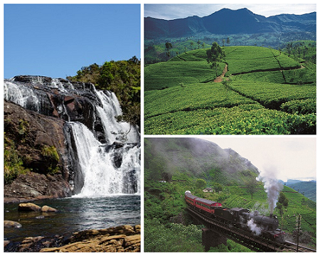
Nuwara Eliya is a picturesque hill station located in the central highlands of Sri Lanka. Known as “Little England,” it boasts a charming colonial-era atmosphere with its cool climate, lush greenery, and beautifully manicured gardens. Situated at an elevation of around 1,868 meters (6,128 feet) above sea level, Nuwara Eliya offers breathtaking views of misty mountains, cascading waterfalls, and tea plantations that stretch as far as the eye can see.
Unlike the tropical climate prevalent in most parts of Sri Lanka, Nuwara Eliya experiences a cool and temperate climate throughout the year. The average temperatures range from 15 to 20 degrees Celsius (59 to 68 degrees Fahrenheit), providing relief from the heat and creating an ideal environment for flora and fauna that thrive in such conditions.
Nuwara Eliya is surrounded by majestic mountains and hills, creating a picturesque backdrop. The mist-covered peaks, such as Pidurutalagala, Sri Lanka’s highest mountain, add to the area’s natural beauty.
The region is dotted with numerous enchanting waterfalls that cascade down the mountains. Some of the well-known waterfalls include St. Clair’s Falls, Devon Falls, and Ramboda Falls. These natural wonders provide captivating sights and create a serene atmosphere.
- Mountains and Plains in Nuwara Eliya – Nature of Nuwara Eliya
- Waterfalls in Nuwara Eliya – Nature of Nuwara Eliya
Mountains and Plains in Nuwara Eliya – Nature of Nuwara Eliya
Nuwara Eliya unveils a breathtaking tapestry of natural beauty where mountains and plains converge in perfect harmony. Towering peaks, adorned in emerald-green tea plantations, stretch towards the heavens, their lofty silhouettes often shrouded in a delicate veil of mist that imparts an ethereal quality to the landscape. Rolling plains, adorned with vibrant fields and picturesque farms, spread out beneath the watchful gaze of these majestic mountains, creating a captivating contrast of rugged grandeur and pastoral serenity.
As the first rays of dawn kiss the dew-kissed grass and the verdant hills, Nuwara Eliya reveals itself as a true paradise for nature lovers, a place where the beauty of mountains and plains intertwine to create an enchanting tableau that inspires awe and wonder.
For more info- https://srilankatravelplaces.com/beautiful-mountains-and-waterfalls/
Horton Plains National Park
The Horton Plains National Park is a protected area located in the central highlands of Sri Lanka, approximately 28 kilometers (17 miles) southeast of Nuwara Eliya. It is situated at an altitude of about 2,100 to 2,300 meters (6,900 to 7,500 feet) above sea level and spans an area of approximately 31 square kilometers (12 square miles).
The park is renowned for its rich biodiversity and unique ecosystems. It is home to a variety of flora and fauna, including many endemic and endangered species. The montane cloud forests, grasslands, and freshwater ecosystems within the park support a diverse range of plants, birds, mammals, reptiles, and amphibians.
World’s End: One of the park’s most famous attractions is World’s End, a sheer cliff with a drop of about 880 meters (2,900 feet). It offers breathtaking panoramic views of the surrounding landscapes, including mist-covered mountains and valleys. On a clear day, you can even see the distant southern coastline from this vantage point.
Trails and Hiking: Horton Plains National Park features several well-marked trails that allow visitors to explore its natural beauty on foot. The most popular trail is the circular route that takes you to World’s End, passing through Baker’s Falls and other notable viewpoints. The trek provides an opportunity to witness the park’s diverse landscapes, encounter wildlife, and immerse yourself in the tranquility of nature.
Wildlife: The park is home to various species of animals, including sambar deer, purple-faced langur monkeys, wild boar, and endemic birds like the Sri Lanka whistling thrush and Sri Lanka bush warbler. The open grasslands provide an ideal habitat for birdwatching, and you may spot species such as the Sri Lanka blue magpie and yellow-eared bulbul.
Conservation Efforts: Horton Plains National Park is a designated UNESCO World Heritage site and is protected to preserve its unique ecosystems and biodiversity.
Visiting Horton Plains National Park offers a remarkable experience of untouched wilderness, stunning landscapes, and the opportunity to connect with nature in its purest form.
Moon Plains
Moon Plains is an exquisite nature reserve located near Nuwara Eliya in Sri Lanka. Also known as “Sandathenna” or “Mini World’s End,” Moon Plains is a scenic plateau nestled amidst the misty mountains of the central highlands.
Landscape and Views: Moon Plains offers breathtaking panoramic views of the surrounding hills, valleys, and tea estates. The undulating terrain is adorned with lush greenery, colorful wildflowers, and occasional patches of forests. The elevated vantage point allows visitors to witness the beauty of Nuwara Eliya’s landscape from a unique perspective.
Mini World’s End: Moon Plains is renowned for its own version of World’s End, a cliff with a sheer drop that provides a bird’s-eye view of the picturesque landscapes. While not as steep as the main World’s End in Horton Plains, this viewpoint offers a similar awe-inspiring experience, allowing visitors to marvel at the vastness of the valleys below.
Biodiversity: Moon Plains is home to diverse flora and fauna. Visitors can spot various species of birds, including the Sri Lanka whistling thrush, yellow-eared bulbul, and Indian blue robin. The grasslands attract several small mammals and reptiles, adding to the biodiversity of the area.
Activities: Moon Plains offers a range of activities for nature enthusiasts and adventure seekers. Guided nature walks and hikes are popular, allowing visitors to explore the area’s natural beauty and wildlife. Additionally, there are opportunities for horse riding and mountain biking, allowing for a more adventurous exploration of the landscape.
Moon Plains offers a serene and tranquil escape from the hustle and bustle of city life. With its stunning views, unique landscapes, and opportunities for adventure and exploration, it has become a popular destination for nature lovers and travelers seeking a peaceful retreat in the heart of Nuwara Eliya’s natural beauty.
Pidurutalagala
Pidurutalagala, also known as Mount Pedro, is the highest peak in Sri Lanka. Located in the central highlands near Nuwara Eliya, it stands at an impressive elevation of 2,524 meters (8,281 feet) above sea level.
Pidurutalagala holds the distinction of being the highest point in Sri Lanka. Its summit offers breathtaking views of the surrounding landscapes, including the rolling hills, tea plantations, and distant mountain ranges. On clear days, it is possible to see as far as the southern coast from the summit.
Climate: Due to its high elevation, Pidurutalagala experiences a cool and often misty climate. The temperature at the summit can be significantly lower than the surrounding areas, and visitors often experience a refreshing change in weather when they ascend the mountain.
Communication Tower: At the peak of Pidurutalagala, there is a communication tower that serves as a significant landmark. It houses transmission facilities for radio and television stations, providing coverage to a wide area of Sri Lanka.
Trekking and Exploration: Pidurutalagala offers opportunities for trekking and exploration for those seeking an adventure. Trekking to the summit allows hikers to experience the mountain’s natural beauty up close and enjoy the panoramic vistas. It is important to note that access to the summit may require permission from the Sri Lankan authorities.
Pidurutalagala is not only a natural landmark but also holds cultural and historical significance for the people of Sri Lanka. It serves as a symbol of the country’s stunning landscapes and offers an opportunity for outdoor enthusiasts to immerse themselves in the beauty of the central highlands.
Thotupola Kanda
Thotupola Kanda is the third highest mountain in Sri Lanka, reaching an elevation of approximately 2,357 meters (7,733 feet) above sea level. Its height makes it one of the noteworthy peaks in the country.
Location: Thotupola Kanda is situated within the Horton Plains National Park, approximately 28 kilometers (17 miles) southeast of Nuwara Eliya. The park is known for its stunning landscapes, including grassy plains, dense forests, and breathtaking viewpoints.
Scenic Beauty: The mountain offers breathtaking panoramic views of the surrounding area, including the rolling hills, valleys, and distant mountain ranges. On clear days, visitors can enjoy vistas that stretch for miles, showcasing the natural beauty of the region.
Hiking and Trekking: Thotupola Kanda offers opportunities for hiking and trekking enthusiasts. There are trails that lead to the summit, allowing visitors to experience the beauty of the mountain and the surrounding landscapes up close. Hiking to the peak can be a rewarding adventure, offering stunning views along the way.
Thotupola Kanda is a captivating destination within the Horton Plains National Park, offering a combination of natural beauty, panoramic views, and hiking opportunities. It is an ideal place for nature lovers, adventure seekers, and those seeking tranquility amidst Sri Lanka’s stunning hill country.
Kirigalpotta
Kirigalpotta reaches an impressive height of approximately 2,388 meters (7,835 feet) above sea level, making it the second highest peak in Sri Lanka. Its towering presence adds to the scenic beauty of the region.
Location: Kirigalpotta is situated within the Horton Plains National Park, which is approximately 32 kilometers (20 miles) southeast of Nuwara Eliya. The park is known for its diverse landscapes, including grassy plains, cloud forests, and stunning viewpoints.
Hiking and Trekking: Kirigalpotta offers an exciting opportunity for hiking and trekking enthusiasts. The mountain has a well-defined trail that leads to its summit, providing adventurers with a challenging yet rewarding experience. Hiking to the peak allows visitors to immerse themselves in the natural beauty of the area and enjoy panoramic views along the way.
Scenic Beauty: From the summit of Kirigalpotta, visitors are rewarded with breathtaking panoramic views of the surrounding landscapes. The rolling hills, mist-covered mountains, and distant valleys create a mesmerizing vista that showcases the beauty of Sri Lanka’s central highlands.
Wildlife and Flora: The area around Kirigalpotta is home to diverse wildlife and flora. The montane forests and grasslands provide habitat for a range of species, including endemic birds, mammals, and plant life. Birdwatchers may spot species such as Sri Lanka whistling thrush, yellow-eared bulbul, and Sri Lanka bush warbler.
Kirigalpotta offers an enchanting experience for nature lovers and outdoor enthusiasts, with its towering presence, hiking opportunities, and panoramic views. It is a prime destination for those seeking to explore the natural wonders of Sri Lanka’s central highlands.
Kudahagala
Kudahagala, also known as Agrabopat Hills, is a mountain located near the Nuwara Eliya district in Sri Lanka. It is considered the fourth tallest mountain in the country, reaching an elevation of approximately 2,320 meters (7,612 feet) above sea level. The mountain offers impressive views and is visible from the nearby Horton Plains National Park, adding to the scenic beauty of the area.
With its elevated position, Kudahagala provides panoramic vistas of the surrounding landscapes, including the rolling hills, valleys, and lush greenery. The cool climate and misty atmosphere in the region contribute to the allure of the mountain.
While Kudahagala may not be as well-known as some of the other peaks in Sri Lanka, it offers a unique perspective for nature enthusiasts and those who appreciate scenic beauty. The mountain’s proximity to the renowned Horton Plains National Park further enhances its appeal, providing opportunities for visitors to explore and immerse themselves in the natural wonders of the area.
#Nature of Nuwara Eliya#Mountains and Plains in Nuwara Eliya#srilankatravelplaces.com#
Waterfalls in Nuwara Eliya – Nature of Nuwara Eliya
Nuwara Eliya is a realm of enchanting waterfalls that dance through the emerald landscapes with unparalleled grace. Here, nature’s artistry takes center stage as crystalline ribbons of water cascade down from rugged cliffs, their graceful descent creating a mesmerizing symphony of sound and motion. The falls, like cascading curtains of liquid silk, plunge into azure pools below, inviting weary travelers to immerse themselves in the refreshing embrace of their cool, clear waters. Each waterfall, whether it be the iconic Ramboda Falls, the hidden treasures of Bomburu Ella, or the serenity of Devon Falls, unveils its unique charm, offering a glimpse into the wondrous tapestry of Nuwara Eliya’s natural beauty, where the serene whispers of falling waterfalls resonate in the hearts of all who behold them.
For more info- https://srilankatravelplaces.com/beautiful-mountains-and-waterfalls/
St. Clair’s Falls
St. Clair’s Falls, also known as St. Clair Falls or Little Niagara of Sri Lanka, is a breathtaking waterfall located near Nuwara Eliya in Sri Lanka.
Location: St. Clair’s Falls is situated in the Talawakele area, approximately 3 kilometers (1.9 miles) west of the town of Hatton, which is about a 30-minute drive from Nuwara Eliya. It is part of the central highlands of Sri Lanka, known for its scenic beauty and tea plantations.
Height and Formation: St. Clair’s Falls is a tiered waterfall consisting of two main segments. The total height of the falls is approximately 80 meters (260 feet). The upper segment is known as “Maha Ella” (Greater Fall), and the lower segment is called “Kuda Ella” (Smaller Fall).
Scenic Beauty: The waterfall is known for its stunning beauty, surrounded by lush greenery and tea estates. The cascading water plunges down the rock face, creating a mesmerizing sight and a soothing sound. The mist and spray from the falls add to the enchanting atmosphere.
Accessibility: St. Clair’s Falls can be viewed from the main road that passes by. There are viewpoints and platforms along the road that offer good vantage points to admire the falls and capture photographs. However, getting closer to the falls may require venturing onto private property, so it’s advisable to respect any signage and boundaries.
St. Clair’s Falls is a must-visit destination for nature lovers and photography enthusiasts. Its picturesque setting, surrounded by tea plantations and the cascading waterfall, creates a serene and captivating experience.
Devon Falls
Location: Devon Falls is situated in the Talawakele area, approximately 7 kilometers (4.3 miles) west of the town of Hatton, which is about a 30-minute drive from Nuwara Eliya. It is nestled in the central highlands of Sri Lanka, known for its scenic beauty and tea plantations.
Height and Formation: Devon Falls is a stunning single-drop waterfall that plunges from a height of approximately 97 meters (318 feet). The water cascades down the rocky cliff face, creating a breathtaking sight and a refreshing mist.
Scenic Beauty: The waterfall is surrounded by lush greenery, tea estates, and picturesque landscapes. The combination of the cascading water, the verdant surroundings, and the misty atmosphere adds to the enchanting beauty of Devon Falls.
Accessibility: Devon Falls can be viewed from the main road that passes by. There are viewpoints and platforms along the road that offer good vantage points to admire the falls and capture photographs. However, it may not be possible to get too close to the waterfall without venturing onto private property, so it’s important to respect any signage and boundaries.
Tea Plantations: The area around Devon Falls is known for its scenic tea estates. Visitors can take in the beauty of the tea plantations and enjoy the serenity of the surroundings. Some tea estates offer guided tours where visitors can learn about the tea-making process and indulge in a cup of freshly brewed Ceylon tea.
Bomburu Ella Falls
Bomburu Ella Falls, also known as Perawella Falls is recognized as the widest waterfall in Sri Lanka. It is formed by the confluence of about 10 small waterfalls, creating a magnificent display of cascading water. The width of the waterfall adds to its impressive natural beauty.
Location and Accessibility: Bomburu Ella Falls is located approximately 14 kilometers (8.7 miles) from the main city of Nuwara Eliya. To reach the falls, visitors may need to hike through the forest, which offers scenic views along the way. It’s important to wear appropriate hiking shoes as the trail can be slippery, especially in muddy conditions.
Hiking Experience: The hike to Bomburu Ella Falls is an adventure in itself. As you make your way through the forest, you’ll have the opportunity to appreciate the natural surroundings and enjoy the serene ambiance. The hike allows you to immerse yourself in the beauty of Sri Lanka’s landscapes.
Natural Beauty: The Bomburu Ella Falls offers a captivating sight with its multiple streams of water cascading down from a height of approximately 2,000 meters (6,560 feet) above sea level. The lush greenery, the sound of rushing water, and the mist created by the falls contribute to the picturesque beauty of the surroundings.
Laxapana Falls
Location: Laxapana Falls is situated in the Maskeliya area, approximately 16 kilometers (10 miles) northeast of Nuwara Eliya. It is nestled in the central highlands of Sri Lanka, amidst lush greenery and tea plantations.
Height and Formation: Laxapana Falls is a stunning single-drop waterfall that descends from a height of approximately 126 meters (413 feet). The water plunges down the rocky cliff face, creating a dramatic and picturesque scene.
Scenic Beauty: The waterfall is surrounded by breathtaking natural beauty, with dense forests, rolling hills, and tea estates in the backdrop. The cascading water, amidst the greenery, adds to the charm of Laxapana Falls and offers a refreshing sight.
Hydroelectric Power Station: Laxapana Falls is not only a natural wonder but also a significant source of hydroelectric power in Sri Lanka. At the base of the waterfall, there is a hydroelectric power station that harnesses the energy from the falling water to generate electricity.
Laxapana Falls offers a captivating experience for nature enthusiasts and those seeking to immerse themselves in the natural beauty of Sri Lanka’s central highlands. With its impressive height, lush surroundings, and the added significance of hydroelectric power generation, Laxapana Falls showcases the wonders of nature and human ingenuity.
Baker’s Waterfall
Location: Baker’s Waterfall is located within Horton Plains National Park, which is situated near Nuwara Eliya in Sri Lanka. It can be accessed from the towns of Pattipola or Ohiya.
Access: From Pattipola, there is a well-signed footpath that leads to Baker’s Waterfall. You can choose to follow the footpath to World’s End and then loop back to the waterfall or take a right turn at the start of the path to head directly to the waterfall.
Hiking Experience: The hike to Baker’s Waterfall offers a scenic and adventurous experience. As you make your way along the footpath, you’ll encounter beautiful landscapes, including the renowned World’s End viewpoint. The path to the waterfall may involve navigating a steep and root-strewn bank, which can be challenging, especially during wet weather. It’s advisable to wear appropriate footwear and exercise caution during the hike.
Natural Beauty: Baker’s Waterfall presents a picturesque sight, with water cascading down a rocky cliff. The surrounding area is typically lush and green, adding to the serene ambiance. It’s a tranquil spot where visitors can enjoy the beauty of nature.
Horton Plains National Park: Baker’s Waterfall is located within Horton Plains National Park, known for its diverse ecosystems, including grassy plains, cloud forests, and unique flora and fauna. The park offers opportunities for wildlife spotting and enjoying the natural surroundings.
Visiting Baker’s Waterfall in Horton Plains National Park provides a chance to immerse yourself in the beauty of Sri Lanka’s central highlands. The hike to the waterfall, combined with the scenic landscapes and the presence of other attractions like World’s End, makes it a worthwhile destination for nature lovers and hikers.
Lover’s Leap
Location: Lover’s Leap is situated on a hill near Nuwara Eliya, a popular hill station in the central highlands of Sri Lanka. It offers panoramic views of the surrounding landscapes and is known for its romantic ambiance.
Height and View: Lover’s Leap provides a stunning vantage point from which visitors can enjoy breathtaking views of the tea estates, valleys, and misty mountains of Nuwara Eliya. It offers a bird’s-eye view of the picturesque scenery, creating a romantic and tranquil atmosphere.
Legend and Name: Lover’s Leap derives its name from a local legend associated with the place. According to the folklore, a young woman leaped off the cliff from this viewpoint due to a tragic love story. The name “Lover’s Leap” reflects this tale and adds a touch of romance to the location.
Access: Lover’s Leap can be reached by car or on foot. There is a road leading to the viewpoint, and parking facilities are available nearby. Visitors can also opt to hike up to the viewpoint, enjoying the natural surroundings along the way.
Photography and Relaxation: Lover’s Leap provides a perfect setting for photography enthusiasts to capture stunning landscapes and panoramic views. It’s also an ideal spot for relaxation, where visitors can soak in the beauty of the surroundings and enjoy peaceful moments in the midst of nature.
Lover’s Leap in Nuwara Eliya is a charming viewpoint that offers mesmerizing views and a romantic atmosphere. Whether you visit for the picturesque landscapes, to learn about the local legend, or to enjoy a peaceful escape, Lover’s Leap provides a memorable experience amidst the natural beauty of Sri Lanka’s hill country.
Ramboda Falls
Location: Ramboda Falls is situated in the Ramboda area, approximately 28 kilometers (17 miles) southeast of Nuwara Eliya. It is nestled amidst the scenic landscapes of Sri Lanka’s central highlands.
Height and Formation: Ramboda Falls is a twin waterfall, consisting of two parallel streams of water that cascade down the rocky cliffs. The combined height of the falls is approximately 109 meters (358 feet), making it an impressive sight.
Scenic Beauty: The waterfall is surrounded by lush greenery, tea plantations, and misty mountains, creating a picturesque backdrop. The cascading water, against the verdant landscapes, adds to the natural beauty of Ramboda Falls.
Accessibility: Ramboda Falls can be easily accessed from the main road that passes by the falls. There are viewpoints and platforms along the road that offer good vantage points to admire the falls and capture photographs. Some places may charge a small fee for entry and parking.
Nearby Attractions: Ramboda Falls is in close proximity to other attractions in the area, such as the Ramboda Tunnel, Sri Bhakta Hanuman Temple, and the beautiful tea estates. These attractions provide additional opportunities for exploration and sightseeing.
Tea Plantations: The region surrounding Ramboda Falls is renowned for its tea plantations. Visitors can enjoy the scenic beauty of the tea estates, take guided tours to learn about tea production, and savor freshly brewed Ceylon tea.
Aberdeen Falls
Location: Aberdeen Falls is located approximately 16 kilometers (10 miles) from Ginigathhena, which is around a two-hour drive from Nuwara Eliya. It is nestled amidst the picturesque landscapes of the central highlands of Sri Lanka.
Height and Formation: Aberdeen Falls is a stunning single-drop waterfall with a height of approximately 98 meters (322 feet). The water gracefully cascades down the rocky cliff, creating a mesmerizing sight.
Scenic Beauty: The waterfall is surrounded by lush greenery, dense forests, and rolling hills, adding to its natural beauty. The tranquil ambiance and the sound of cascading water make it a serene and peaceful spot.
Accessibility: To reach Aberdeen Falls, you can take a scenic drive from Ginigathhena. There is a designated viewpoint near the waterfall that offers a good vantage point to admire and photograph the falls. It is advisable to exercise caution while visiting as the paths near the waterfall may be slippery.
Nature and Wildlife: The area around Aberdeen Falls is known for its rich biodiversity. Nature enthusiasts can enjoy the flora and fauna in the surrounding forests, which are home to a variety of bird species and other wildlife.
Visiting Aberdeen Falls offers an opportunity to immerse yourself in the natural beauty of Sri Lanka’s central highlands. The majestic waterfall, combined with the lush green landscapes, creates a scenic and tranquil setting that is worth exploring.
Nanuoya Waterfall
Location: Nanuoya Waterfall is located approximately 6 kilometers from Nuwara Eliya, a popular hill station in Sri Lanka’s central highlands. It is situated in close proximity to the Mahaweli and Kotmale rivers.
Height and Formation: Nanuoya Waterfall is about 60 meters (197 feet) high and consists of a series of 25 steps or cascades. The water gracefully flows down these steps, creating a beautiful sight and adding to the allure of the waterfall.
Scenic Beauty: The waterfall is surrounded by lush greenery, offering a picturesque and tranquil environment. Visitors can enjoy the calm breeze, refreshing water, and the natural beauty of the surroundings. It’s a perfect spot to relax and take in the serene atmosphere.
Scenic Views: Nanuoya Waterfall offers stunning scenic views of the surrounding landscapes. Visitors can admire the lush green surroundings and enjoy the peaceful ambiance while taking in the beauty of the area.
Nanuoya Waterfall provides a serene and scenic escape from the bustling city. With its beautiful cascades, tranquil atmosphere, it is a delightful spot to unwind and appreciate the natural beauty of Sri Lanka’s central highlands.
Dunsinane Waterfall
Dunsinane Waterfall (also known as Pundalu Oya Ella) is located in the Pundalu Oya area, which is the nearest town. It is situated between the Dunsinan and Sheen tea plantations in the vicinity.
Height and Formation: Dunsinane Waterfall is an impressive waterfall, standing approximately 100 meters (328 feet) tall. It cascades down in a series of steps, creating a stunning visual spectacle. The waterfall’s flow eventually joins the Pundalu Oya, Kotmale River, and the Kotmale Reservoir.
Segments and Views: The waterfall is divided into two segments, separated by a road bridge. The top segment can be properly viewed from the bridge, as it falls over a wide rocky ledge, creating a sheet of water cascading down a 30-meter (98-foot) drop. However, the second segment, which is approximately 70 meters (230 feet) high, remains hidden below the bridge.
Difficulty of Access: Due to the steepness and the designated high-security zone related to the Upper Kotmale Project, accessing the bottom of the waterfall and the area covering the river below can be challenging. This may limit the ability to explore the entire waterfall and its surroundings.
Dunsinane Waterfall, also known as Pundalu Oya Ella, offers a magnificent display of cascading water and is surrounded by the scenic beauty of the tea plantations. While the top segment can be viewed from the bridge, accessing the lower segment and the river area may be restricted. It remains a natural attraction for those visiting the Pundalu Oya area and provides a glimpse into the picturesque landscapes of Sri Lanka’s central highlands.
Kolapathana Ella Waterfall
Location: Kolapathana Ella Waterfall is situated in the small ancient village of Mandaram Nuwara in the Nuwara Eliya district of Sri Lanka. Mandaram Nuwara is located at the foot of the Pidurutalagala Mountain, at an altitude of 1250 meters (4101 feet) above sea level.
Height: The exact height of Kolapathana Ella Waterfall is unknown, but it is believed to be not less than 50 meters (164 feet). The waterfall is fed by a stream that originates from the Pidurutalagala Mountain, which is the highest peak in Sri Lanka.
Scenic Beauty: Kolapathana Ella Waterfall is known for its natural beauty and picturesque surroundings. The cascading water, combined with the lush greenery and mountainous landscapes, creates a serene and tranquil atmosphere.
Access: To reach Kolapathana Ella Waterfall, you can travel from Nuwara Eliya along the Nuwara Eliya-Uda Pussellawa Road. The road passes through Kandapola and leads up to Mandaram Nuwara, where the waterfall is situated. Follow the road to reach the waterfall and enjoy its splendor.
Kolapathana Ella Waterfall offers a scenic escape and an opportunity to immerse yourself in the natural beauty of the Nuwara Eliya district. Its location in the ancient village of Mandaram Nuwara adds to the charm and provides a glimpse into the local culture and surroundings.
#Nature of Nuwara Eliya# waterfalls in Nuwara Eliya#srilankatravelplaces.com#
Add a Comment