Matale is a picturesque city located in the Central Province of Sri Lanka. Known for its breathtaking natural beauty, Matale is nestled amidst lush green hills, misty mountains, and fertile valleys. The region’s geography is dominated by rolling tea estates, cascading waterfalls, and abundant vegetation, creating a serene and tranquil environment. Nature enthusiasts can venture into the nearby Knuckles Mountain Range, which offers spectacular trekking and hiking opportunities.
Matale is blessed with a moderate climate, with cool temperatures throughout the year, making it a popular destination for nature enthusiasts and those seeking respite from the tropical heat. The region’s diverse flora and fauna thrive in this favorable climate, offering a rich and vibrant ecosystem.
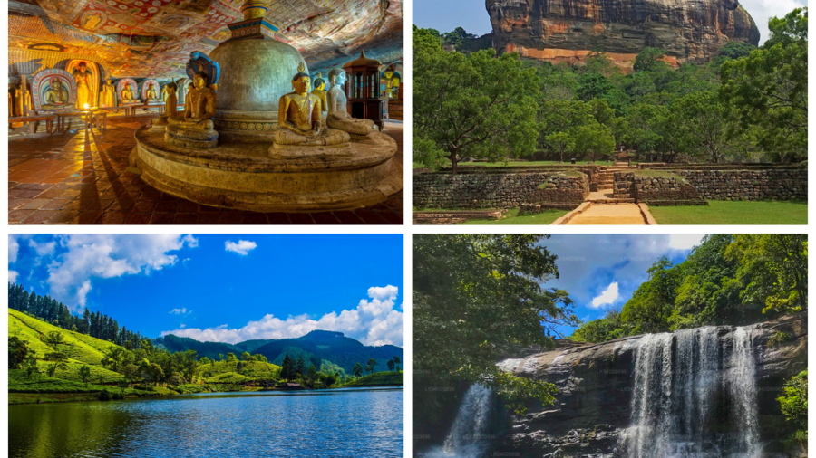
- Knuckles Mountain Range
- Riverstone Gap
- Pidurangala Rock
- Sembuwatta Lake
- Sera Ella Falls
- Hunnasgiriya Falls (Hunnas Waterfall)
- Ramboda Falls
Knuckles Mountain Range
The Knuckles Mountain Range is a prominent geographical landmark located in Matale District, Sri Lanka. Also known as the Knuckles Massif or Dumbara Kanduvetiya in Sinhala, it is a part of the Central Highlands of Sri Lanka and is a UNESCO World Heritage Site.
Geography: The Knuckles Mountain Range spans an area of about 155 square kilometers and is situated in the northeastern region of Matale District. It is named after its unique resemblance to a clenched fist or a set of knuckles.
Elevation: The highest peak in the range is known as “Knuckles” or “Kirigalpoththa,” which stands at an impressive 1,858 meters (6,096 feet) above sea level. It is the second-highest peak in Sri Lanka after Pidurutalagala.
Biodiversity: The Knuckles Mountain Range is renowned for its rich biodiversity and serves as a vital conservation area. It is home to a wide variety of flora and fauna, including many endemic and endangered species. The region contains diverse ecosystems ranging from cloud forests to grasslands and is an important watershed for several major rivers.
Hiking and Trekking: The Knuckles Mountain Range offers numerous opportunities for hiking and trekking enthusiasts. The area features an extensive network of trails, allowing visitors to explore its natural beauty and enjoy breathtaking panoramic views along the way. The challenging terrain and diverse landscapes attract both local and international hikers.
Cultural Significance: In addition to its natural beauty, the Knuckles Mountain Range holds cultural and historical importance. It is inhabited by local communities, including indigenous people who have maintained their traditional ways of life for generations. These communities contribute to the cultural heritage of the region.
Conservation and Protection: Due to its ecological significance and biodiversity, the Knuckles Mountain Range was declared a UNESCO World Heritage Site in 2010. It is protected under the Knuckles Conservation Forest, which ensures the preservation of its natural resources and promotes sustainable tourism practices.
Visiting the Knuckles Mountain Range provides an opportunity to experience the stunning landscapes, explore diverse ecosystems, encounter unique wildlife, and immerse oneself in the local culture of Sri Lanka. It is advisable to plan your visit with a reputable tour operator or guide to ensure a safe and enjoyable experience.
Riverstone Gap
Riverstone Gap, also known as Pitawala Pathana, is a picturesque location situated in the Matale District of Sri Lanka. It is a popular tourist destination known for its breathtaking landscapes, panoramic views, and abundant natural beauty.
Location: Riverstone Gap is located in the Knuckles Mountain Range, which is part of the Central Highlands of Sri Lanka. It is approximately 30 kilometers from Matale town and can be accessed via a scenic drive through winding roads surrounded by tea plantations and lush greenery.
Scenic Beauty: Riverstone Gap is renowned for its stunning landscapes, characterized by rolling hills, misty mountains, cascading waterfalls, and vast grasslands. The area offers panoramic views of the surrounding valleys, mountains, and the Knuckles Mountain Range itself. It is a paradise for nature lovers and photographers.
Hiking and Trekking: The region around Riverstone Gap offers excellent opportunities for hiking and trekking. There are several trails that lead to viewpoints and natural attractions, allowing visitors to explore the area’s beauty on foot. The most popular trek is the Riverstone-Meemure trail, which takes you through tea estates, forests, and offers spectacular views along the way.
Mini World’s End: One of the major attractions in Riverstone Gap is the Mini World’s End viewpoint. It offers a breathtaking view of the surrounding landscapes, with misty mountains stretching out as far as the eye can see. It is a popular spot to capture stunning photographs.
Pitawala Pathana: Pitawala Pathana is a vast grassland located near Riverstone Gap. It is a unique ecosystem that provides a contrast to the dense forests and tea plantations in the area. Visitors can take leisurely walks, have picnics, and enjoy the serene ambiance of the grassland.
Biodiversity: Riverstone Gap is home to a diverse range of flora and fauna. The area is rich in birdlife, and birdwatchers can spot several species of endemic and migratory birds. It is also a habitat for many endemic plant species, making it an important conservation area.
Climate: Riverstone Gap enjoys a cool and pleasant climate throughout the year due to its higher elevation. The temperature remains relatively mild, and the area experiences occasional mists and drizzles, adding to its charm.
When visiting Riverstone Gap, it is recommended to wear comfortable clothing and suitable footwear for hiking or walking. Carrying water, snacks, and insect repellent is also advisable. The best time to visit is during the dry season, which typically spans from December to March, as the weather is generally clearer and more favorable for outdoor activities.
Pidurangala Rock
Pidurangala Rock is a popular tourist attraction located in Sigiriya, Sri Lanka. It is situated just a few kilometers north of the famous Sigiriya Rock Fortress. While Sigiriya Rock is known for its ancient palace ruins and beautiful frescoes, Pidurangala Rock offers a different experience to visitors.
Pidurangala Rock is a massive rock formation that offers panoramic views of the surrounding countryside, including the Sigiriya Rock Fortress. It is a popular spot for hiking and offers a challenging but rewarding climb to its summit.
One of the highlights of Pidurangala Rock is the breathtaking sunrise and sunset views it offers. Many visitors choose to hike early in the morning to witness the sunrise from the top of the rock.
Overall, Pidurangala Rock is a must-visit destination for nature lovers, adventure seekers, and photography enthusiasts who want to experience panoramic views of the Sri Lankan countryside and witness spectacular sunrises or sunsets.
Sembuwatta Lake
Sembuwatta Lake is situated about 20 kilometers from the town of Matale, in the central part of Sri Lanka. It is nestled amidst lush green hills and tea plantations, providing a picturesque setting.
The lake was created in the 19th century as a result of a natural spring. The name “Sembuwatta” is derived from the Sinhala words “Sembu” (tiger) and “Watta” (rock), referring to the shape of the rocks surrounding the lake that resemble a resting tiger.
Sembuwatta Lake is known for its breathtaking beauty and tranquil atmosphere. Surrounded by dense forests, the lake offers stunning views of the surrounding hills and valleys. Visitors often admire the reflection of the surrounding landscape on the calm waters of the lake.
The lake is a popular destination for nature lovers and outdoor enthusiasts. Visitors can engage in a range of activities, including boating, Zip Lining ,picnics, hiking, and nature trails etc. Boating in traditional paddle boats is a popular choice for exploring the lake and enjoying the serene surroundings.
Whether you are a nature enthusiast, a photographer looking for stunning vistas, or simply seeking a peaceful retreat, Sembuwatta Lake in Matale is a must-visit destination. Its natural beauty, refreshing waters, and tranquil surroundings make it a true gem in Sri Lanka’s landscape.
Sera Ella Falls
Sera Ella falls is situated in the Dumbara Jungle, approximately 18 kilometers from Matale town in the Matale District of Sri Lanka. It is nestled amidst the central hills of the country.
The waterfall is formed by the waters of the Kitul Canal, which originates from the slopes of Mount Mainstone. Sera Ella falls cascades down from a height of about 30 meters (98 feet), creating a breathtaking sight.
The waterfall is formed by the waters of the Kitul Canal, which originates from the slopes of Mount Mainstone. Sera Ella falls cascades down from a height of about 30 meters (98 feet), creating a breathtaking sight.
Hunnasgiriya Falls (Hunnas Waterfall)
Hunnasgiriya Waterfall, also known as Hunnas Falls, is a scenic waterfall is situated in the central highlands of Sri Lanka, near the town of Elkaduwa, which is about 22 kilometers from Matale town. It is surrounded by picturesque landscapes and lush greenery.
The waterfall is formed by the waters of Hunnasgiriya Oya, a tributary of the Kala Oya. It cascades down from a height of approximately 50 meters (164 feet), creating a breathtaking sight.
Hunnasgiriya Waterfall is known for its natural beauty and serene surroundings. The lush vegetation, misty atmosphere, and the sound of cascading water make it a tranquil and picturesque spot.
The waterfall can be reached by traveling along the Kandy-Matale Road and taking a turn towards Hunnasgiriya. From there, a short drive and a hike will lead you to the waterfall. The journey to the waterfall offers beautiful views of the surrounding countryside.
Visitors can enjoy various activities at Hunnasgiriya Waterfall. These include taking in the breathtaking views, capturing photographs, enjoying a picnic by the waterfall, or simply relaxing amidst the tranquil atmosphere.
Ramboda Falls
Ramboda Falls is situated approximately 28 kilometers from Nuwara Eliya town, in the Ramboda area of Matale District. It is located along the A5 highway that connects Nuwara Eliya and Kandy.
Ramboda Falls is formed by the Panna Oya, a tributary of the Kotmale River. It cascades down from a height of about 109 meters (358 feet), making it one of the tallest waterfalls in Sri Lanka.
There are viewpoints and observation decks near Ramboda Falls that allow visitors to get a closer look at the waterfall. These vantage points offer panoramic views of the cascades and the surrounding landscapes. The area is also a popular spot for sightseeing, with visitors enjoying the scenic views and the sound of rushing water. Additionally, there are facilities such as parking areas, shops, and small restaurants nearby to cater to the needs of visitors.
Add a Comment